


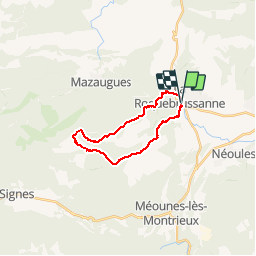
La Roquebrussane-Jas du murier

francisdean
User


5h21
Difficulty : Medium

FREE GPS app for hiking
 SityTrail
IGN / Geographical institutes
SityTrail Plus
The world is yours!
About
Trail Walking of 18.4 km to be discovered at Provence-Alpes-Côte d'Azur, Var, La Roquebrussanne. This trail is proposed by francisdean.
Description
Il n'y a pas de balisage pour cette randonnée.Suivre le tracé à l'aide du GPS. A partir du Jas du Murier, ne pas essayer de raccourcir par le Mas Fa René dont le propriétaire interdit le passage sur SES terres !! En bas, après le vallon des cerisiers et la descente raide qui arrive à la rivière, rejoignez la route en passant sur l'arrosant qui traverse l'Issole. Ne pas passer sur le pont qui mène vers un portail fermé.
Positioning
Comments
demain